EGL2 is under construction and is expected to be operational in 2029.
You can find out more about the infrastructure in England by looking at our interactive map.
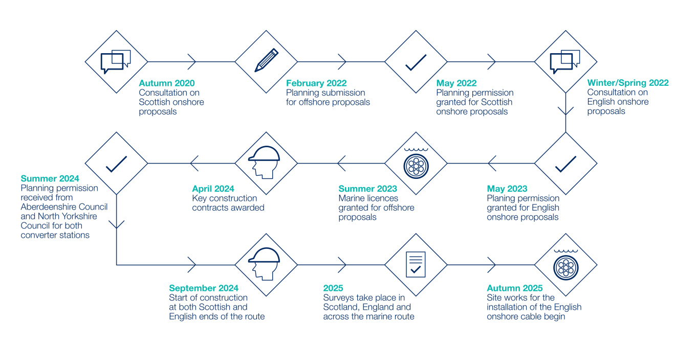
Project timeline
Community updates
To build EGL2, we carry out a range of activities such as surveys, access works and construction.
At times, this may affect local roads and access. To keep everyone safe, we may use:
-
Traffic lights
-
Temporary road closures
-
Managed access.
These measures help protect road users, reduce damage to local roads and keep traffic moving safely.
You can find details of current and upcoming works in the tables below.
Scotland construction activities
|
Works
|
Location
|
Measures in place
|
Expected timings
|
Link to more information
|
|
Extended weekend working hours
|
Peterhead
|
7am - 5pm Saturday 8am - 5pm Sunday |
Saturday 19 July 2025 - March 2026
|
|
English construction activities
|
Works |
Location |
Measures in place |
Expected timings |
Link to more information
|
|
Extended working hours
|
Wren Hall Converter Station
|
8am - 5pm on Sundays
|
Until March 2027
|
|
|
Trenching works
|
Beverley Road and Lund Wold Road, East Riding
|
Temporary road closures with diversions
|
Monday 27 July for approximately 2 weeks
|
|
|
Bellmouth installation
|
B1228, near Station Road, East Riding
|
Temporary stop and go boards
|
Wednesday 5 August for approximately 1 week
|
|
|
Bellmouth installation
|
Wood Lane, Howden, East Riding
|
Temporary stop and go boards
|
Monday 27 July for approximately 3 weeks
|
|
|
Cable works |
Kilnwick Road, Middleton- on-the-Wolds, East Riding |
Temporary road closure |
Tuesday 14 July for up to 2 week
|
|
Archived community updates
|
Works |
Location |
Measures in place |
Expected timings |
Link to more information
|
|
Peterhead Substation underground cabling works
|
Peterhead
|
No impact to access to adjacent pedestrian footpaths or U66. Short closure (approximately 10 days) of adjacent unnamed road to the West of Peterhead Substation. |
Monday 19 January 2026 - for approximately 4 months
|
|
|
Continuous concrete pours
|
Peterhead
|
Overnight works and site illumiation.
|
Thursday 8 - Friday 9 January 2026 Monday 19 January - Sunday 1 February 2026 |
|
|
Landfall site enabling works
|
Sandford Bay, Peterhead
|
No disruption to public access to the beach at Sandford Bay. Access maintained to the footpath adjacent to the A90.
|
Friday 17 October 2025
|
|
|
Marine surveys |
Sandford Bay, Boddam, Peterhead |
No disruption to public access to the beach at Sandford Bay |
Late May - October 2025 |
Project update |
|
Repair of tactile paving at pedestrian crossing |
U66/A90 Junction, Peterhead |
Three-way traffic lights |
Saturday 11 - Sunday 12 October 2025 |
N/A |
|
Utility survey |
U66 |
Road closure of a section of road close to Peterhead Converter Station site entrance |
Sunday 5 October 2025 |
N/A |
|
Overnight traffic management |
A90 U66 |
Overnight traffic lights in various locations |
Monday 5 - Friday 9 May 2025 (10pm to 6am) |
Project update |
|
Geophysical surveys |
Sandford Bay and surrounds |
No traffic impact |
Monday 3 - Friday 14 February 2025 |
|
|
Water connection works |
Adjacent to A90 |
Southbound lane closure |
Monday 13 - Tuesday 21 January 2025 |
|
|
Water and sewage connections |
A90 |
2-hour traffic management |
Monday 12 - Friday 23 August 2024 |
N/A |
|
Ducts installation |
U66 C64B |
Road closure |
U66: Thursday 13 – 30 June 2024 C64B: Saturday 13 – Sunday 15 June 2024 |
N/A |
|
132 kV cable undergrounding
|
U66 |
Road closure |
Sunday 17 – Wednesday 27 March 2024 Monday 18 – Friday 29 March 2024 |
N/A |
|
11 kV cable undergrounding and rerouting |
A90 U66 |
Traffic management |
Wednesday 21 - Wednesday 28 February 2024 |
N/A |
|
Works |
Location |
Measures in place |
Expected timings |
Link to more information |
| Cable installation works | Carr Lane and Nafferton Beck, Wansford, East Riding | N/A | Saturday 11 July - Sunday 12 July | Traffic management map |
| Bellmouth installation | Lock Lane, Tollingham, East Riding | Temporary road closure | Monday 8 June for a week | Traffic management map |
| Completion of overhead line refurbishment works | Between Drax and Eggborough | Temporary traffic measures and temporary public rights of way closures | Completed in June 2026 | Completion of works postcard |
| Bellmouth installation | Barmby Road, Barmby on the Marsh, East Riding | Temporary road closure | Thursday 28 May for a week | Traffic management map |
| Bellmouth installation | Howden Road, Bursea Lane Ends, East Riding | Two-way traffic light management system | Friday 18 May for a week | Traffic management map |
| Bellmouth installation repairs | Gransmoor Lane, Gransmoor, East Riding | Temporary road closure and diversion | Friday 8 May for up to two weeks | Traffic management map |
| Bellmouth installation | Out Gates, Nafferton, East Riding | Temporary road closure and diversion | 30 April for up to two weeks | Traffic management map |
| Bellmouth installation | Skiff Lane, Tollingham, East Riding | Two-way traffic light management system with temporary traffic lights and a lane closure | Tuesday 7 April for up to two weeks | Traffic management map |
| Bellmouth installation | Wansford Rad, East Riding | Temporary road closure and diversion | Thursday 26 March for up to weeks | Traffic management map |
| Bellmouth installation | Beverley Road and Holme Wold Road, East Riding | Temporary road closures and diversions | Monday 16 March and Friday 20 March for up to two weeks | Traffic management map |
| Piling works | Wren Hall converter station site | N/A | Monday 2 March - Friday 24 April | Resident postcard |
| Piling works | Wren Hall Converter Station site | N/A | December 2025 - Monday 19 January 2025 | Resident postcard |
| Piling works | Wren Hall Converter Station site | N/A | Monday 7 April 2025 onwards | Resident postcard |
| Bellmouth installation | Holme Road, Portington, East Riding | Two-way traffic light management system with temporary traffic lights and a lane closure | Monday 23 February for up to two weeks | Traffic management map |
| Bellmouth installation | Bursea Lane, Bursea, East Riding | Temporary road closure and diversion | Friday 27 February for up to two weeks | Traffic management map |
| Bellmouth installation | A614, Spaldington, East Riding | Two-way traffic light management system with temporary traffic lights and a lane closure | Monday 23 February for up to two weeks | Traffic management map |
| Bellmouth installation | Holme on the Wolds and Dalton, Kiplingcotes Racecourse | Two-way traffic light management system with temporary traffic lights and a lane closure | Friday 13 February - Wednesday 18 February | Traffic management map |
| Vegetation clearance | Chestercourt Lane, East Riding | Temporary road closure and diversion | Thursday 12 February - Friday 13 February | Traffic management map |
| Vegetation clearance | Selby Road (A1041), East Riding | Two way traffic light management system | Tuesday 10 February - Wednesday 11 February | Traffic management map |
| Vegetation clearance | Barlow Road, East Riding | Temporary road closure and diversion | Monday 9 February - Wednesday 11 February | Traffic management map |
| Bellmouth installation | Carr Lane, Nafferton, Wansford, East Riding | Two-way traffic light management system with temporary traffic lights and a lane closure | Monday 2 February - Tuesday 10 February | Traffic management map |
| Bellmouth installation | Arras Hill, Market Weighton, East Riding | Two-way traffic light management system with temporary traffic lights and a lane closure | Wednesday 28 January - Wednesday 4 February | Traffic management map |
| Bellmouth installation | Lund Wold Road, East Riding | Temporary road closure and diversion | Monday 26 January - Friday 30 January | Traffic management map |
| Vegetation clearance | Common Lane, East Riding | Temporary road closure and diversion | Wednesday 21 January - Sunday 25 January | Traffic management map |
| Bellmouth installation | Wansford Road, Nafferton, East Riding | Temporary road closure and diversion | Tuesday 20 January - Tuesday 27 January | Traffic management map |
| Vegetation clearance | Camela Lane, East Riding | Temporary road closure and diversion | Monday 19 January - Friday 23 January | Traffic management map |
| Bellmouth installation | Cliffe Road, Market Weighton, East Riding | Three-way traffic management system with temporary traffic lights and a lane closure | Monday 19 January - Tuesday 27 January | Traffic management map |
| Bellmouth installation | Beverley Road, Middleton, Lund, East Riding | Temporary road closure and diversion | Monday 19 January - Tuesday 27 January | Traffic management map |
| Vegetation clearance | Wand Lane, East Riding | Two way traffic light system | Wednesday 14 January - Thursday 15 January | Traffic management map |
| Bellmouth installation | Sand Lane, South Cliffe, East Riding | Temporary road closure and diversion | Monday 12 January - Tuesday 20 January | Traffic management map |
| Bellmouth installation | Burnbutts Lane, Hutton Cranswick | Temporary road closure and diversion | Monday 12 January - Monday 19 | Traffic management map |
| Machinery movement | Lund Wold Road, East Riding | Temporary road closure for 15 minutes between 9am - 12pm | Friday 12 December | N/A |
| Machinery movement | Lund Wold Road, East Riding | Temporary road closure for 15 minutes between 9am - 12pm | Wednesday 3 December | N/A |
| Vegetation clearance | Chestercourt Lane, East Riding | Temporary road closure and diversion | Monday 1 December - Friday 5 December | Traffic management map |
| Machinery movement | Out Gates, Harpham, Lowthorpe, East Riding | Temporary road closure for 15 minutes between 9am - 12pm | Friday 28 November | N/A |
| Bellmouth installation | Sancton Road, Market Weighton, East Riding | Two-way traffic management system with temporary traffic lights | Monday 24 November - Tuesday 9 December | Traffic management map |
| Bellmouth installation | Wansford Road, Nafferton, East Riding | Temporary road closure and diversion | Tuesday 18 November - Tuesday 25 November | Traffic management map |
| Bellmouth installation | Arras Hill, Market Weighton, East Riding | Two-way traffic management system with temporary traffic lights | Monday 10 November - Monday 17 November |
Traffic management map |
| Vegetation clearance | Sand Lane, South Cliffe East Riding | Cones placed at point of works to maintain a safe working area | Monday 27 October | N/A |
| Bellmouth installation | Station Road, Middleton, Bainton, East Riding | Two-way traffic management system with temporary traffic lights | Monday 20 October - Friday 31 October | Traffic management map |
| Bellmouth installation | Hords Lane Nafferton, East Riding | Temporary road closure and diversion | Wednesday 15 October - Wednesday 22 October | Traffic management map |
| Vegetation clearance | Sancton Road, Market Weighton, East Riding | Cones placed at point of works to maintain a safe working area | Monday 13 October | N/A |
| Vegetation clearance | Station Road, Middleton, Bainton, East Riding | Two-way traffic management system with temporary traffic lights | Wednesday 8 October - Monday 13 October | Traffic management map |
| Bellmouth installation | Sancton Road, Market Weighton, East Riding | Two-way traffic management system with temporary traffic lights | Tuesday 7 October - Monday 20 October | Traffic management map |
| Vegetation clearance | Arras Hill, Market Weighton, East Riding | Cones placed at point of works to maintain a safe working area | Friday 3 October | N/A |
| Vegetation clearance | Etton, East Riding | Cones placed at point of works to maintain a safe working area | Thursday 2 October | N/A |
|
Marine surveys |
Near to Bridlington, East Riding |
No disruption to public access to the beach at Fraisthorpe |
June - October 2025 |
Marine newsletter |
| Bellmouth installation | Beverley Road, Hutton Cranswick, East Riding | Two-way traffic management system with temporary traffic lights | Monday 29 September - Tuesday 14 Octobe | Traffic management map |
| Vegetation clearance | Beverley Road, Middleton, Lund, East Riding | Cones placed at point of works to maintain a safe working area | Thursday 25 September | N/A |
| Vegetation clearance | Middleton, Middleton on the Wolds, East Riding | Cones placed at point of works to maintain a safe working area | Thursday 18 September | N/A |
| Machinery movement | Middleton-on-the-Wolds, Lund Wold Road, East Riding | 15 minute delay | Thursday 11, Monday 15 and Monday 22 September | N/A |
| Vegetation clearance | Station Road, Middleton, Bainton, East Riding | Cones placed at the point of works to maintain a safe working area | Monday 8 September | N/A |
| Vegetation clearance | Beverley Road, Hutton Cranswick, East Riding | Cones placed at the point of works to maintain a safe working area | Friday 5 September | N/A |
| Bellmouth installation | Jenkinson Lane, Hutton Cranswick, East Riding | Temporary road closure and diversion | Tuesday 2 September - Monday 8 September | Traffic management map |
| Vegetation clearance | Jenkinson Lane, Hutton Cranswick, East Riding | Cones placed at the point of works to maintain a safe working area | Monday 1 September | N/A |
| Vegetation clearance | Gransmoor, Burton Agnes, East Riding | Cones placed at the point of works to maintain a safe working area | Monday 1 September | N/A |
|
Bellmouth installation |
Fraisthorpe, Barmston, East Riding |
Two-way traffic management system with temporary traffic lights |
Monday 25 August - Monday 1 September 2025 |
Traffic management map |
|
Bellmouth installation |
Driffield Road, Skerne, East Riding |
Temporary road closure and diversion |
Monday 25 August - Monday 1 September 2025 |
Traffic management map |
|
Vegetation clearance |
Burnbutts Lane, Hutton Cranswick, East Riding |
Cones placed at the point of works to maintain a safe working area |
Friday 22 August 2025 |
N/A |
|
Bellmouth installation |
Hutton Cranswick, Southburn, East Riding |
Temporary road closure and diversion |
Monday 18 - Friday 22 August 2025 |
Traffic management map |
|
Vegetation clearance |
Driffield Road, Skerne, East Riding |
Cones placed at the point of works to maintain a safe working area |
Thursday 21 August 2025 |
N/A |
|
Vegetation clearance |
Carr Lane, Nafferton, East Riding |
Cones placed at the point of works to maintain a safe working area |
Friday 15 August 2025 |
N/A |
|
Vegetation clearance |
Hutton Cranswick, Southburn, East Riding |
Cones placed at the point of works to maintain a safe working area |
Wednesday 13 August 2025 |
N/A |
|
Bellmouth installation |
Gransmoor Lane, Great Kelk, East Riding |
Temporary road closure and diversion |
Monday 11 - Friday 15 August 2025 |
Traffic management map |
|
Vegetation clearance |
Wansford Road, Nafferton, East Riding |
Cones placed at the point of works to maintain a safe working area |
Friday 8 August 2025 |
N/A |
|
Ground surveys |
New Road, Drax |
Two-way traffic management system with temporary traffic lights |
Monday 23 -Friday 27 June 2025 |
N/A |
|
Machinery movement |
Wood Lane, Howden, East Riding |
Temporary road closure for 15 minutes between 9am - 12pm |
Friday 20 June 2025 |
N/A |
|
Machinery movement |
Wood Lane, Howden, East Riding |
Temporary road closure for 15 minutes between 9am - 12pm |
Thursday 19 June 2025 |
N/A |
|
Machinery movement |
Dalton Holme, East Riding |
Temporary road closure for 15 minutes between 9am - 12pm |
Tuesday 17 June 2025 |
N/A |
|
Utilities works |
Wren Hall Lane, Drax |
Road closure (managed by Northern Powergrid) |
Monday 7 April - Monday 16 June 2025 |
N/A |
|
Machinery Movement |
Fisher Street, Dalton Holme, East Riding of Yorkshire |
Temporary road closure for 15 minutes between 9am - 12pm |
Wednesday 11 June 2025 |
N/A |
|
Machinery movement |
Outgates Wansford, East Riding |
Temporary road closure for 15 minutes from 8am to 10am |
Friday 6 June 2025 |
N/A |
|
Machinery movement |
Hutton Cranswick, Southburn, East Riding |
Temporary road closure for 15 minutes from 8am to 10am |
Friday 6 June 2025 |
N/A |
|
Machinery movement |
Skiff Lane, Holme-upon-Spalding-Moor, East Riding |
Temporary road closure for 15 minutes from 8am to 12pm |
Friday 6 June 2025 |
N/A |
|
Machinery movement |
Skiff Lane, Holme-upon-Spalding-Moor, East Riding |
Temporary road closure for 15 minutes from 8am to 6pm |
Wednesday 4 June 2025 |
N/A |
|
Machinery movement |
Main Street, Little Kelk, Great Kelk, East Riding |
Temporary road closure for 15 minutes from 8am to 10am |
Wednesday 4 June 2025 |
N/A |
|
Machinery movement |
Wansford Road, Nafferton, East Riding |
Temporary road closure for 15 minutes from 8am to 10am |
Wednesday 28 May 2025 |
N/A |
|
Machinery movement |
Outgates, Wansford, East Riding |
Temporary road closure for 15 minutes from 8am to 10am |
Tuesday 27 May 2025 |
N/A |
|
Machinery movement |
Hutton Cranswick, Southburn, East Riding |
Temporary road closure for 15 minutes from 8am to 10am |
Tuesday 27 May 2025 |
N/A |
|
Machinery movement |
Skiff Lane, Holme-upon-Spalding-Moor, East Riding |
Temporary road closure for 15 minutes from 8am to 10am |
Tuesday 27 May 2025 |
N/A |
|
Vegetation clearance |
Fraisthorpe, Barmston, East Riding |
Two-way traffic management system with temporary traffic lights |
Wednesday 21 May 2025 |
N/A |
|
Machinery movement |
Sancton Road, Market Weighton, East Riding |
Temporary road closure for 15 minutes |
Tuesday 20 May 2025 |
N/A |
|
Vegetation clearance |
Sancton Road, Market Weighton, East Riding |
Two-way traffic management system with temporary traffic lights |
Thursday 15 - Friday 16 May 2025 |
Traffic management map |
|
Vegetation clearance |
Skerne and Wansford, Skerne, East Riding |
Two-way traffic management system with temporary traffic lights |
Monday 12 - Friday 16 May 2025 |
Traffic management map |
|
Machinery movement |
Gransmoor, Burton Agnes, East Riding |
Temporary road closure for 15 minutes between 9am to 12pm |
Monday 15 May 2025 |
N/A |
|
Machinery movement |
Hutton Cranswick, Southburn, East Riding |
Temporary road closure for 15 minutes between 9am to 12pm |
Tuesday 13 May 2025 |
N/A |
|
Machinery movement |
Wansford Road, Nafferton, East Riding |
Temporary road closure for 15 minutes between 9am to 12pm |
Monday 12 May 2025 |
N/A |
|
Vegetation clearance |
Wansford Road, Nafferton, East Riding |
Stop and go traffic management |
Friday 9 - Tuesday 13 May 2025 |
Traffic management map |
|
Machinery movement |
Gransmoor Lane, Kelk, Great Kelk, East Riding |
Temporary road closure and diversion |
Wednesday 7 May 2025 |
N/A |
|
Machinery movement |
Jenkinson Lane, Hutton Cranswick, East Riding |
Two-way traffic management system with temporary traffic lights |
Wednesday 7 May 2025 |
N/A |
|
Machinery movement |
Skerne and Wansford, Skerne, East Riding |
Temporary road closure for 15 minutes between 9am to 12pm |
Monday 28 April 2025 |
N/A |
|
Machinery movement |
Sancton Road, Market Weighton, East Riding |
Two-way traffic management system with temporary traffic lights |
Thursday 24 April 2025 |
N/A |
|
Machinery movement |
Cliffe Road/Long Lane, Market Weighton, East Riding |
Temporary road closure for 15 minutes between 9am to 12pm |
Thursday 24 April 2025 |
N/A |
|
Machinery movement |
Station Road, Middleton, Bainton, East Riding |
Temporary road closure for 15 minutes between 9am to 12pm |
Wednesday 16 April 2025 |
N/A |
|
Ground surveys |
Howden Road, Holme upon Spalding Moor, East Riding |
Two-way traffic management system with temporary traffic lights |
Monday 14 - Wednesday 16 April |
Traffic management map |
|
Ground surveys |
Sleights Lane, Eastrington, East Riding |
Road closure and diversion |
Thursday 10 - Monday 14 April 2025 |
Traffic management map |
|
Ground surveys |
Bursea Lane, Holme upon Spalding Moor, East Riding |
Road closure and diversion |
Tuesday 8 - Thursday 10 April 2025 |
Traffic management map |
|
Ground surveys |
Drain Lane, Holme upon Spalding Moor, East Riding |
Road closure and diversion |
Monday 7 - Thursday 10 April 2025 |
Traffic management map |
|
Ground surveys |
Lock Lane, Holme upon Spalding Moor, East Riding |
Road closure and diversion |
Monday 7 - Wednesday 9 April 2025 |
Traffic management map |
|
Ground surveys |
Kiplingcotes Lane, Goodmanham, East Riding |
Road closure and diversion |
Monday 31 March - Wednesday 2 April 2025 |
Traffic management map |
|
Ground surveys |
Spring Road, Etton, East Riding |
Road closure and diversion |
Monday 31 March - Wednesday 2 April 2025 |
Traffic management map |
|
Ground surveys |
Fisher Street, Etton, Lund, East Riding |
Road closure and diversion |
Monday 31 March - Wednesday 2 April 2025 |
Traffic management map |
|
Ground surveys |
Kiplingcotes Racecourse, East Riding |
Road closure and diversion |
Monday 31 March - Wednesday 2 April 2025 |
Traffic management map |
|
Ground surveys |
Holme Wold Road, Dalton Holme, Lund, East Riding |
Road closure and diversion |
Monday 31 March - Wednesday 2 April 2025 |
Traffic management map |
|
Ground surveys |
Lund, East Riding |
Road closure and diversion |
Thursday 27 March - Tuesday 1 April 2025 |
Traffic management map |
|
Ground surveys |
Middleton, Middleton on the Wolds, East Riding |
Road closure and diversion |
Thursday 27 - Monday 31 March 2025 |
Traffic management map |
|
Ground surveys |
Jenkinson Lane, Hutton Cranswick, East Riding |
Road closure and diversion |
Tuesday 25 - Thursday 27 March 2025 |
Traffic management map |
|
Ground surveys |
Burnbutts Lane, Hutton Cranswick, Bainton, East Riding |
Road closure and diversion |
Monday 24 - Monday 31 March 2025 |
Traffic management map |
|
Ground surveys |
Out Gates, Harpham, Lowthorpe, East Riding |
Road closure and diversion |
Monday 24 - Wednesday 26 March 2025 |
Traffic management map |
|
Ground surveys |
Hutton Cranswick, Southburn, East Riding |
Road closure and diversion |
Tuesday 18 - Friday 21 March 2025 |
Traffic management map |
|
Machinery movement |
Beverley Road, Middleton, Lund, East Riding |
Temporary road closure for 15 minutes between 9am to 12pm |
Tuesday 18 March 2025 |
N/A |
|
Machinery movement |
Etton, East Riding |
Temporary road closure for 15 minutes between 9am to 12pm |
Tuesday 18 March 2025 |
N/A |
|
Machinery movement |
Middleton, Middleton on the Wolds, East Riding |
Temporary road closure for 15 minutes between 9am to 12pm |
Tuesday 18 March 2025 |
N/A |
|
Machinery movement |
Burnbutts Lane, Hutton Cranswick, Bainton, East Riding |
Temporary road closure for 15 minutes between 9am to 12pm |
Tuesday 18 March 2025 |
N/A |
|
Ground surveys |
Carr Lane, Nafferton, Wansford, East Riding |
Road closure and diversion |
Thursday 13 – Wednesday 19 March 2025 |
Traffic management map |
|
Machinery movement |
Burnbutts Lane, Hutton Cranswick, Bainton, East Riding |
Temporary road closure for 15 minutes between 9am to 12pm |
Monday 10 – Wednesday 12 March 2025 |
N/A |
|
Ground surveys |
Hords Lane, Nafferton, Wansford, East Riding |
Temporary road closure |
Monday 3 – Friday 14 March 2025 |
N/A |
|
Machinery movement |
Etton, East Riding of Yorkshire |
15 minute delay |
Monday 3 March 2025 |
N/A |
|
Ground surveys |
Station Road, Middleton, Bainton, East Riding |
Two-way traffic management system with temporary traffic lights |
Monday 24 – Friday 28 February 2025 |
Traffic management map |
|
Ground surveys |
B1249, Skerne and Wansford, East Riding |
Two-way traffic management system with temporary traffic lights |
Friday 14 – Tuesday 18 February 2025 |
|
|
Geophysical surveys |
Fraisthorpe Sands |
No impact to public access |
Monday 10 – Friday 14 February 2025 |
N/A |
|
Ground surveys |
Main Street, Little Kelk, Great Kelk, East Riding |
Three-way stop and go traffic management system |
Thursday 6 - Monday 10 February 2025 |
N/A |
|
Ground surveys |
Gransmoor Lane, Great Kelk, East Riding |
Stop and go traffic management system |
Wednesday 5 – Monday 10 February 2025 |
N/A |
|
Ground surveys |
Gransmoor Lane, Great Kelk, East Riding |
Stop and go traffic management system |
Tuesday 4 - Wednesday 5 February 2025 |
N/A |
|
Ground surveys |
Redhouse Lane, Long Drax, Drax, North Yorkshire, |
Two-way traffic management system with temporary traffic lights |
Tuesday 28 – Thursday 30 January 2025 |
|
|
Ground surveys |
Hull Road, Newsholme, East Riding |
Two-way traffic management system with temporary traffic lights |
Monday 27 - Wednesday 29 January 2025 |
|
|
Ground surveys |
B1228, Howden, East Riding |
Two-way traffic management system with temporary traffic lights |
Thursday 23 – Monday 27 January 2025 |
|
|
Ground surveys |
A614, Spaldington, East Riding |
Two-way traffic management system with temporary traffic lights |
Wednesday 22 - Friday 24 January 2025
|
|
|
Ground surveys |
Wood Lane, Howden, East Riding |
Two-way traffic management system with temporary traffic lights |
Tuesday 21 – Thursday 23 January 2025 |
|
|
Ground surveys |
A614, Spaldington, East Riding |
Two-way traffic management system with temporary traffic lights |
Tuesday 21 – Thursday 23 January 2025
|
|
|
Ground surveys |
Cliffe Road, Market Weighton, East Riding |
Three-way traffic management system with temporary traffic lights |
Monday 20 - Thursday 23 January 2025 |
|
|
Ground surveys |
Skiff Lane, Holme upon Spalding Moor, East Riding |
Stop and go traffic management system |
Monday 13 – Wednesday 15 January 2025 |
N/A |
|
Ground surveys |
Sand Lane, North Cliffe, south of Market Weighton, East Riding |
Three-way stop and go traffic management system |
Monday 13 – Friday 15 January 2025 |
N/A |
|
Ground surveys |
Beverley Road, Hutton Cranswick |
Two-way traffic management system with temporary traffic lights |
Wednesday 15 – Friday 17 January 2025
|
|
|
Ground surveys |
Arras Hill, Market Weighton |
Two-way traffic management system with temporary traffic lights and lane closures |
Thursday 16 – Monday 20 January 2025 |
|
|
Early survey works for the installation of a construction compound |
Sancton Road (A1034), Market Weighton |
Two-way traffic management system with temporary traffic lights |
Tuesday 26 – Saturday 30 November 2024 |
|
|
Wren Hall Converter Station site access |
Wren Hall Lane, Drax, North Yorkshire |
Road closure |
Tuesday 22 October – Monday 11 November 2024 |
|
|
Wren Hall Converter Station site access |
New Road, Drax, North Yorkshire |
Three-way traffic management system with temporary traffic lights |
Monday 9 September – Sunday 13 October 2024 |
What we are constructing in your area
Overview
The Peterhead Converter Station will convert electricity between AC and DC so it can be transported efficiently. It forms a key connection point between the offshore cable and the wider electricity network in Scotland.
Completed works
-
Construction started in October 2024
-
Access roads, drainage and site facilities installed
-
Platform completed in summer 2025
-
Extended working hours introduced for key activities.
Upcoming works
-
Drilling works beneath the coastline
-
Continued construction of buildings
-
Offshore activity near landfall
-
Installation of onshore cable.
Working hours
-
Monday to Friday: 7am - 7pm
-
Saturday: 7am - 5pm
-
Sunday: 8am - 5pm
These extended working hours are expected to continue into early 2026. Where possible, noisier works are scheduled during daytime hours.
Overview
The marine element includes a 436 km subsea cable linking Peterhead in Scotland to Bridlington in England.
The cable will be installed offshore using specialist vessels and carefully planned methods.
We are currently carrying out surveys to understand seabed conditions and plan the safest installation route.

Completed works:
-
Surveys to understand seabed and ground conditions
-
Safety checks along the offshore route
-
investigations at landfall sites to confirm the best installation method
-
Environmental and noise assessments.
Upcoming works (2026):
-
Further offshore and nearshore surveys
-
Ground investigations to support design
-
Preparation of landfall sites
-
Targeted safety surveys along the route.
Summer 2026 update:
During summer 2026, preparation works for Horizontal Directional Drilling (HDD) will begin in Yorkshire. This will include site mobilisation, the installation of fencing and the establishment of a secure working area. A drilling platform will also be constructed onshore to enable HDD works to take place later in the year.
There will be no offshore cable installation in 2026.
For more information on the landfall site at Sandford Bay, Peterhead, please see the Peterhead area section.
Working hours
Marine activity depends on weather and tides. Work may take place at different times.
No permanent offshore structures will be installed in 2026.
From Fraisthorpe Sands, the cable runs underground for around 68 km to Drax. We will use a mix of trenching and trenchless methods to reduce disruption. 2026 is a key preparation year, with significant enabling and construction works taking place along the route.
Completed works
-
Route surveys
-
Trail holes undertaken to check existing utilities
-
Vegetation clearance carried out to create safe temporary access
-
Early haul road works started in limited areas near coast.
Upcoming works
-
Construction of a temporary haul road to reduce construction traffic on local roads
-
Finalising the installation of safe access points (bellmouths) across the haul road
-
Cable installation begins:
-
Horizontal directional drilling (a trenchless method for installing underground cables) beneath roads, rivers and sensitive areas
-
Open-cut trench cable laying (this involves digging a trench, laying the cable and backfilling the area) starting from March 2026, subject to approvals
-
-
Temporary compounds will be set up, including a main compound near Market Weighton, just off Cliffe road.
Working hours
-
Monday to Friday: 7am - 7pm
-
Saturday: 8am -5pm
You may notice temporary traffic management or road closures. We will provide advance notice where needed.
Overview
Wren Hall is a new converter station near Drax Power Station that will connect EGL2 into the wider national grid electricity transmission network. Construction will continue throughout 2026 as the main buildings and equipment are installed.
Completed works
-
Construction started in September 2024
-
Site setup completed
-
Foundations completed
-
Low carbon measures introduced, including solar power and HVO fuel (a cleaner alternative to diesel).
-
Upcoming works
-
Building structures and roofing
-
Internal fit-out
-
Groundworks and drainage
-
Site roads and access.
Working hours
-
Monday to Friday: 7am - 7pm
-
Saturday: 8am - 5pm
Occasional out-of-hours work may be needed. We will give advance notice where this happens.
Overview
We are upgrading existing overhead lines to support increased electricity flows. These upgrades help keep the network safe and reliable.
The upgrades are being delivered in phases to minimise disruption.
Completed works
- Refurbishment of the overhead line between Drax, North Yorkshire and Fenwick, South Yorkshire, completed between May and September 2025
- All footpaths, bridleways and other public rights of way fully reopened and reinstated.
Ongoing works
- Refurbishment of the overhead line between Drax, North Yorkshire and Eggborough, West Yorkshire
- Works began in April 2026 and are expected to continue until June 2026
- Some short-term road and/or public right of way closures may be required, with advance notice provided to our neighbours.
Working hours
Most work will take place during daytime hours.